The MOSAiC research ship drifts amid sea ice this past August. Scientists onboard collected new data about the Arctic.

Steffen Graupner/Alfred-Wegener-Institut, Helmholtz-Zentrum für Polar- und Meeresforschung

STANDARDS

Common Core: RH.6-8.1, RH.6-8.2, RH.6-8.4, RH.6-8.7, WHST.6-8.4, RI.6-8.1, RI.6-8.2, RI.6-8.4, RI.6-8.7, W.6-8.4, SL.6-8.1

NCSS: Time, Continuity, and Change • People, Places, and Environments • Science, Technology, and Society • Global Connections

GEO QUEST

Polar Map

Arctic in Peril

Climate change is dramatically altering Earth’s northernmost region. Scientists involved in a recent expedition there say the impacts will be felt worldwide.  

The Arctic is famous for ice, snow, and giant glaciers—not to mention polar bears. But Earth’s northernmost region is getting an unwelcome makeover, scientists say. New research shows that climate change is shifting Arctic conditions, from snow and ice to rain and ice-free seas. 

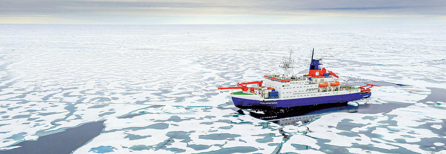
“The ice is only half as thick as it was 40 years ago,” says Markus Rex, a German scientist. Rex recently led a yearlong expedition in the Arctic. 

The international effort, nicknamed MOSAiC, was the largest and longest polar research expedition of its kind. Scientists wanted to learn more about how the Arctic is changing—and why.


Folke Mehrtens/Alfred-Wegener-Institut, Helmholtz-Zentrum für Polar- und Meeresforschung

Expedition scientists weigh snow in the Arctic.

Shrinking Sea Ice

The edges of the Arctic ice cap melt in the summer and then refreeze in the winter. But more of that ice is melting now than in the past, says Ola Persson, a MOSAiC scientist. This past summer, the expedition crew witnessed the second-lowest recorded Arctic sea ice extent—the area of ocean covered by ice (see map, below)

The ice loss is a big factor in why the Arctic is warming twice as fast as the rest of Earth, scientists say. Sea ice’s bright surface reflects approximately 70 percent of the sunlight that reaches it back into space. But dark ocean waters absorb sunlight—soaking up about 90 percent of rays. So as the ice-free area of the Arctic Ocean increases, so does the amount of heat that its waters absorb. 

Plus, with less sea ice staying frozen year-round, there is more new ice in the winter than before. New ice is thinner than old ice, so it is more likely to melt, Persson says.


Steffen Graupner/Alfred-Wegener-Institut, Helmholtz-Zentrum für Polar- und Meeresforschung

Polar bears explore near the ship. The Arctic mammals perch on sea ice to hunt.

Global Impacts

The Arctic’s roughly 4 million residents are already feeling the impacts of sea ice loss. In Alaska, eroding shorelines threaten villages. The changes are also affecting the Arctic ecosystem, including polar bears, which travel across summer sea ice to hunt. 

Without major efforts to halt climate change, Arctic summers could be ice-free within decades, Rex says. As a result, sea levels could rise, affecting coastal communities globally. And heat waves, droughts, and other weather events could last longer. 

But scientists hope the MOSAiC data will spur people worldwide to take action.

“Arctic sea ice is not only an important part of the global climate system, it is also a unique ecosystem and the basis of life for many Indigenous societies,” Rex says. “We should do everything within our power to preserve it.” 


Polar View 

This polar map shows the countries that have territory in the Arctic region. The inset maps compare the extent of sea ice in 1990 and in 2020. First, read about polar maps below. Then use this map and what you have learned to answer the questions below.

Jim McMahon/Mapman®

POLAR MAPS offer flattened views of Earth from directly above one of the two polar regions, the Arctic and the Antarctic. This polar map shows the North Pole—an imaginary point in the Arctic that is the farthest north possible on any map. (The South Pole in the Antarctic is the farthest south.) There is no land at the North Pole, only an ice cap. Polar maps are equidistant projections—maps that show water and landmasses in relation to a central point. The map above has the North Pole as that point, so from any spot, north is toward the center. Equidistant projections show direction and distance correctly. But landmasses appear increasingly distorted as you move away from the center.


MAP SKILLS

1. On this polar map, what is the northernmost point?

2. Part of which U.S. state lies in the Arctic Circle?

3. How many nations have territory bordering or inside the Arctic Circle?

4. The MOSAiC expedition started in Tromsø, Norway. That city is about how many straight line miles from the North Pole?

5. What body of water separates Russia and Alaska at their closest point? 

6. About how many straight-line miles separate the North Pole and Anchorage, Alaska?

7. Which four countries have land north of 80°N latitude?

8. In which direction would a person at the North Pole travel to reach Russia?

9. What city is located at 71°N, 156°W?

10. Was the extent of Arctic sea ice greater in 1990 or 2020?

Check out Map Skills Boot Camp for more geography practice.

videos (1)
Skills Sheets (3)
Skills Sheets (3)
Skills Sheets (3)
Lesson Plan (3)
Lesson Plan (3)
Lesson Plan (3)
Text-to-Speech