
Question: How are researchers helping communities prepare for earthquakes?
Question: How are researchers helping communities prepare for earthquakes?
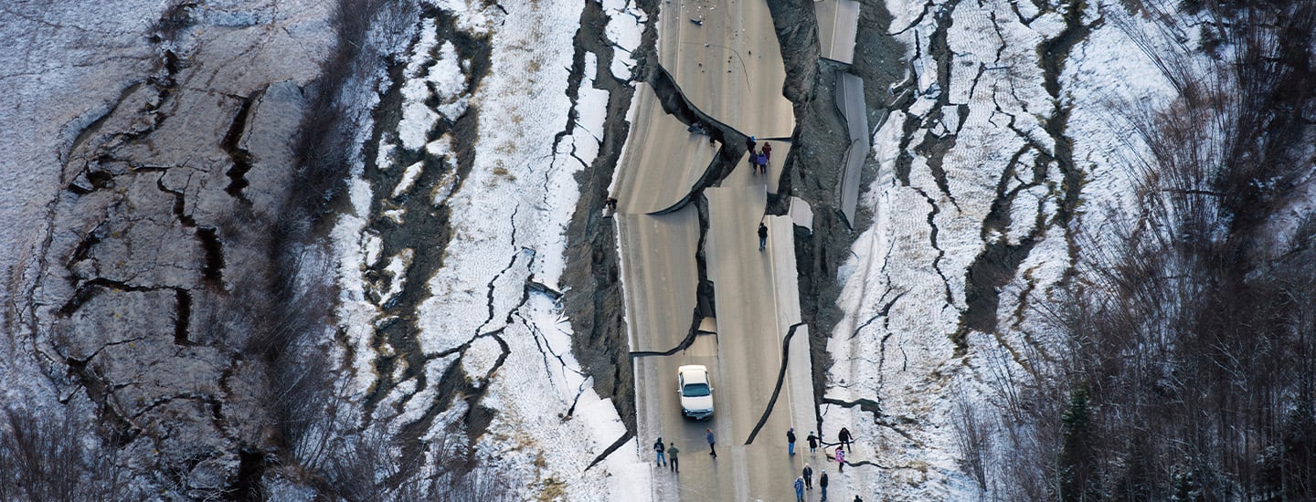
A 7.1-magnitude earthquake tore apart this road in southern Alaska in 2018.
Marc Lester/Anchorage Daily News via AP Images
STANDARDS
NCSS: People, Places, and Environments • Individuals, Groups, and Institutions • Power, Authority, and Governance • Science, Technology, and Society
Common Core: RH.6-8.1, RH.6-8.2, RH.6-8.3, RH.6-8.4, RH.6-8.5, RH.6-8.6, RH.6-8.7, RI.6-8.1, RI.6-8.2, RI.6-8.3, RI.6-8.4, RI.6-8.5, RI.6-8.6, RI.6-8.7, RI.6-8.9
GEOGRAPHY | U.S. NEWS
Shaky Ground
A new study shows most of the United States could experience earthquakes within the next century. Find out what cities and states are doing to keep people safe.
Question: How are researchers helping communities prepare for earthquakes?
Question: How are researchers helping communities prepare for earthquakes?
It seemed like an ordinary spring morning—until it wasn’t. An earthquake struck without warning near Whitehouse Station, New Jersey. It shook the ground throughout the northeastern United States, all the way from Boston, Massachusetts, to Washington, D.C. The tremors could be felt by more than 42 million people. Even New York’s Statue of Liberty swayed from the trembling.
That 4.8-magnitude quake this past April was the strongest earthquake to hit New Jersey in 140 years. And experts say there may be more to come. According to a recent U.S. government report, about 75 percent of the country could experience dangerous shaking from earthquakes over the next century.
It seemed like an ordinary spring morning. Until it was not. An earthquake struck without warning near Whitehouse Station, New Jersey. It shook the ground throughout the northeastern United States, all the way from Boston, Massachusetts, to Washington, D.C. The tremors could be felt by more than 42 million people. Even the Statue of Liberty in New York swayed from the trembling.
That 4.8-magnitude quake hit this past April. It was the strongest earthquake in New Jersey in 140 years. And experts say there may be more to come. About 75 percent of the country could experience dangerous shaking from earthquakes over the next century. That is according to a recent U.S. government report.
Shutterstock.com (Statue of Liberty); Angela Weiss/AFP via Getty Images (alert)
The Statue of Liberty trembled during an earthquake this past April. The earthquake's strength was reported as a magnitude of 4.8 by the U.S. Geological Survey.
Most earthquakes are so mild that they’re not even felt. The New Jersey quake did not cause serious damage. But more powerful earthquakes can collapse buildings, spark fires, and even trigger landslides or flooding.
“If we don’t prepare for earthquakes, they can cause problems,” says Mark Petersen of the U.S. Geological Survey (USGS). He is the lead scientist on the recent report, which pinpointed where earthquakes can happen and how much damage they’re likely to cause. His goal is to help architects, engineers, and city planners identify where to make buildings safer.
Most earthquakes are so mild that they are not even felt. The New Jersey quake did not cause serious damage. But more powerful earthquakes can collapse buildings and spark fires. They can even trigger landslides and flooding.
“If we don’t prepare for earthquakes, they can cause problems,” says Mark Petersen. He is with the U.S. Geological Survey (USGS). Petersen is the lead scientist on the recent report. It pinpointed where earthquakes can happen and how much damage they are likely to cause. His goal is to help architects, engineers, and city planners figure out where to make buildings safer.
Finding Faults
Earthquakes begin underground, in Earth’s crust. The crust is made up of giant, slow-moving slabs of rock called tectonic plates. The plates sometimes collide, pull apart, or slide past each other. That can make the ground above them move and shake. Earthquakes can also occur along old cracks within a tectonic plate. The earthquake-prone spaces between and within plates are called faults.
Many known faults lie along the Pacific Coast, which is why California and Alaska experience more earthquakes than the rest of the country. Southern California has about 10,000 quakes a year, but only a fraction of them are noticeable.
Scientists say other faults remain undetected—especially in the central and eastern U.S. Evidence of such faults has been removed by erosion from streams and long-ago glaciers as well as human development.
Earthquakes begin underground, in Earth’s crust. The crust is made up of giant, slow-moving slabs of rock called tectonic plates. The plates sometimes collide, pull apart, or slide past each other. That can make the ground above them move and shake. Earthquakes can also occur along old cracks within a tectonic plate. The spaces between and within plates—where earthquakes are likely to happen—are called faults.
Many known faults lie along the Pacific Coast. That is why California and Alaska experience more earthquakes than the rest of the country. Southern California has about 10,000 quakes a year. But only a fraction of them are noticeable.
Scientists say other faults remain undetected. That is especially true in the central and eastern U.S. Evidence of such faults has been removed by various causes. Such causes include erosion from streams, long-ago glaciers, and human development.
To determine where future earthquakes could strike, the USGS researchers studied known faults. They also measured current ground movement where earthquakes have occurred. Finally, they analyzed where and when damaging earthquakes have taken place.
What they found surprised them: Within the past 200 years, 37 states have experienced earthquakes that exceeded a magnitude of 5. That number represents a moderate quake, which could result in damage to buildings and other structures.
Scientists also identified about 500 additional faults in the U.S. They found that California and Alaska are at even greater risk than previously thought. The risk in Hawaii is also higher than known before. The state is home to five active volcanoes, and their eruptions can trigger quakes. In addition, scientists learned more about roughly a dozen faults in the eastern U.S.
To figure out where future earthquakes could strike, the USGS researchers studied known faults. They also measured current ground movement where earthquakes have occurred. Finally, they analyzed where and when damaging earthquakes have taken place.
What they found surprised them. Within the past 200 years, 37 states have experienced earthquakes that exceeded a magnitude of 5. That number represents a moderate quake. A moderate quakes is one that could cause damage to buildings and other structures.
Scientists also identified about 500 additional faults in the U.S. They found that California and Alaska are at even greater risk than previously thought. The risk in Hawaii is also higher than known before. That state is home to five active volcanoes. Their eruptions can trigger quakes. In addition, scientists learned more about roughly a dozen faults in the eastern U.S.
Robinson Chavez/Los Angeles Times via Getty Images
Kids in California shelter under their desks during an earthquake drill.
Being Prepared
The USGS team created a map (see below) that forecasts where damaging quakes are most likely to occur. Local governments can use it to determine where precautions should be taken. For example, officials in high-risk areas can require that buildings be designed to sway rather than collapse during an earthquake. Engineers can also design bridges, roads, and dams strong enough to resist shaky ground.
Some of that work is already underway. For example, California has been offering up to $3,000 to some residents to update older homes to be more earthquake-resistant. And in many states, people participate in yearly earthquake drills to learn how to protect themselves if one strikes.
Even with the new map, no one can predict when an earthquake will happen, Petersen says. But taking precautions can help communities stay safe—and recover when the next one hits.
The USGS team created a map (see below) that forecasts where damaging quakes are most likely to occur. Local governments can use the map to figure out where precautions should be taken. For example, officials in high-risk areas can require that buildings be designed to sway instead of collapse during an earthquake. Engineers can also design bridges, roads, and dams strong enough to resist shaky ground.
Some of that work is already underway. For example, California has been offering up to $3,000 to some residents to update older homes to better resist earthquakes. And in many states, people take part in yearly earthquake drills. Those help them learn how to protect themselves if one strikes.
Even with the new map, no one can predict when an earthquake will happen, Petersen says. But taking precautions can help communities stay safe. It can also help them recover when the next one hits.
Interactive Quiz for this article
Click the Google Classroom button below to share the Know the News quiz with your class.
Download .PDF